Jenam Fm
Type Locality and Naming
Middle formation of Barail Gr. Type section is in the Jenam River section. Thickness is 1200 m. [Original Publication: Evans P. 1932. Tertiary succession in Assam, Trans. Min. Geol. Inst., India, vol. 27, pp. 155.]. Reference well: Silchar-Haflong road section, its thickness is 980 m.
Synonyms: The finer clastics represented dominantly by shales with subordinate sandstones overlying Laisong were classified as Jenam stage (Evans,1932). Ranga Rao (1983) has considered this unit as a formation due to its mappability and distinct lithological characteristics, (Pandey and Dave, 1998).
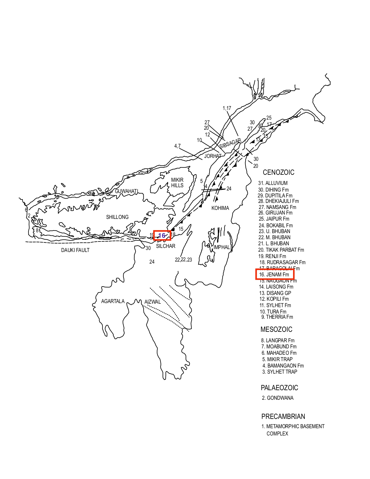
[Figure 1: Formation stratotypes of North East Basins (modified after Pandey and Dave, 1998)
Lithology and Thickness
Sandy claystone. Type section lithology: Jenam Formation gradationally overlies the Laisong Fm. The thin-bedded sandstone, shale and sandy shale alternations present near the base give way to predominantly shales and sandy shale sequence with minor thin-bedded sandstones. Reference section lithology: The Jenam Formation consists of predominantly shale, carbonaceous shale, silty shale with subordinate bands of sandstone. Shale is dark grey to grey with carbonaceous streaks. Sandstone occurs as alternating thin laminae. These are grey to brownish grey, fine to medium grained, well bedded and moderately hard. It is 800 m thickness in the Schuppen Belt. Towards west in the Lubha River section thickness is 861 m. North of the Haflong-Dauki fault system, the thickness, in Prang River section is only 304 m.
[Figure 2: The Jenam turbidites with Bouma sequence T (modal variety), The Jenam Valley (after Dasgupta et al., (1991)]
Relationships and Distribution
Lower contact
The formation has gradational contact with the Laisong Fm.
Upper contact
Gradational contact with the overlying Renji Fm.
Regional extent
Khasi & Jaintia Hills, Naga Schuppen Belt, Tripura Cachar, SE Bangladesh: Jenam Formation is exposed in southwestern part of Schuppen Belt, Kohim and Patkai syclinoria, Barail Range and south-eastern part of Shillong Plateau as a distinct mappable unit. Thin clay conglomerate beds are also observed within the sandstones in some sections exposed in South Shillong Plateau. T owards the west of Silchar-Haflong road, the individual beds tend to thicken towards the top. In Barail Range and Cachar area it consists predominantly of shales with alternating sandstones and maximum thickness observed is 980 m. In the subsurface, it is encountered in the upthrust block of Badarpur structure and is made up of light to dark grey, splintery shale, streaks of coal and carbonaceous matter. The subordinate sandstone associated with it is light grey, very fine to medium grained, micaceous and fairly sorted. In Schuppen Belt, it is predominantly an argillaceous sequence of dark grey, silty shale, and mudstone with thin sand lenticles. Bioturbation, carbonaceous plant material, cross laminations and ripple marks are common. The Baragolai Fm consisting of shales, carbonaceous shales, thin sandstones and coal occupies same stratigraphic position in the area north east of Mokokchung. It is distinguished by dominance of carbonaceous matter, in contrast of Jenam.
GeoJSON
Fossils
A few arenaceous foraminifera are recorded from Schuppen Belt. Palynoflora from Silchar-Haflong road section include Tricholpites reticulates, Mayeripollis naharkotensis, Lygopodium sporites, Biretisporites oligocenicus (Kumar 1962).
Age
Depositional setting
Deltaic Environment
Additional Information

.jpg)